Ramsgate
From wiki new
OPENED: 1-JUL-1895 · CLOSED: 1-NOV-1922
Location: 43° 35′ 0″ South, 146° 52′ 0″ East (N.B. these are the co-ordinates for Cockle Creek)
- Ramsgate was situated approx. 33km SSW of Dover. Nearby post offices were at Catamaran and Leprena during the period of operation
- opened as Recherché Bay 11-MAY-1857 · renamed Ramsgate from 1-JUL-1895
- a Recherche Bay datestamp should exist but is yet to be recorded
- facilities were transferred to Catamaran on 1-NOV-1922 however the datestamp remained in use for a few days after that for reasons unknown

see Google Map for an enlargement - Ramsgate was in the vicinity of where the road crosses Cockle Creek.
Barred Numeral Postmark[edit]
Second Allocation

- BN75 originally allocated to Recherche Bay was used at Ramsgate although it's application to the mail may have been abandoned much earlier than usual for this postmark type
- rarity rating is RRR
- manuscript '75' cancels have been reported
You can provide a better image of this barred numeral postmark here
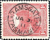
Datestamps[edit]
Type 1 (Circle Stops)
- Error creating thumbnail: File missing

- Earliest recorded date: 9-AUG-1899 · Latest recorded date: 6-NOV-1922
Report an earlier or later use of the Type datestamp here
| To the Index of Tasmanian Post Offices and Postal Markings
To the Tasmanian Datestamp Types main page |
Other Information[edit]
Links & References[edit]
| To the Index of Tasmanian Post Offices and Postal Markings
To the Tasmanian Datestamp Types main page |
Please contact the author of this listing [1] to report any errors and/or omissions or to provide better or 'missing' images, etc.