Stonehenge
From wiki new
___this page is currently being prepared by R.E.___
Location: 42° 24' 0" South, 147° 38' 0" East
- situated approx. 23km SE of Oatlands
- Formerly Dairy Farm; sometimes referred to as "Dairy Farm (Eastern Marshes)"
- the closest post offices to Stonehenge were at Whitefoord and Woodsdale


Click on the RH map for an enlargement
- Re-named Stonehenge: 01-AUG-1881 · Closed: 21-APR-1969
- Operated as a Mail Receiving House until 01-NOV-1883 when it was upgraded to a post office
- Operated as a Mail Receiving House only between 01-JAN-1915 until 30-JUN-1927 and then as a PO again until closure
Datestamps[edit]
Solid stops
- Error creating thumbnail: File missing

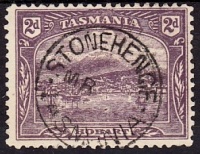
- Earliest recorded date: 09-AUG-1886 · Latest recorded date: 04-SEP-1942
- Rated RR on Tasmanian stamps · Rated R on Commonwealth stamps but only if it is a clear and complete impression (or nearly so)
- Earliest recorded date: 13-JUN-1943 · Latest recorded date: 18-JUN-1959
- Rated RR
- Reported in purple ink during 1948
Original Type 5 cds refitted with a new dateline featuring smaller characters
- Stonehenge type 5(s).jpg
- Earliest recorded date: 02-DEC-1960 · Latest recorded date: 21-APR-1969 (In use until closure)
- Rated RR
- 'Last Day Covers' exist
| To the Index of Tasmanian Post Offices and Postal Markings
To the Tasmanian Datestamp Types main page |
Other Items[edit]

Other Information[edit]
Links & References[edit]
| To the Index of Tasmanian Post Offices and Postal Markings
To the Tasmanian Datestamp Types main page |